A Curious Phenomenon Called ‘Etak’
Every once in a while, a revolutionary product comes along that changes everything. Or so said Steve Jobs when he announced iPhone in 2007.
But I’m talking about a different revolutionary product. A foundational product that forever changed how everyone on this planet gets to where they need to be.
Today, I’d like to tell you about the Etak Navigator, a truly revolutionary product and the world’s first practical vehicle navigation system.
Here’s a picture of it:
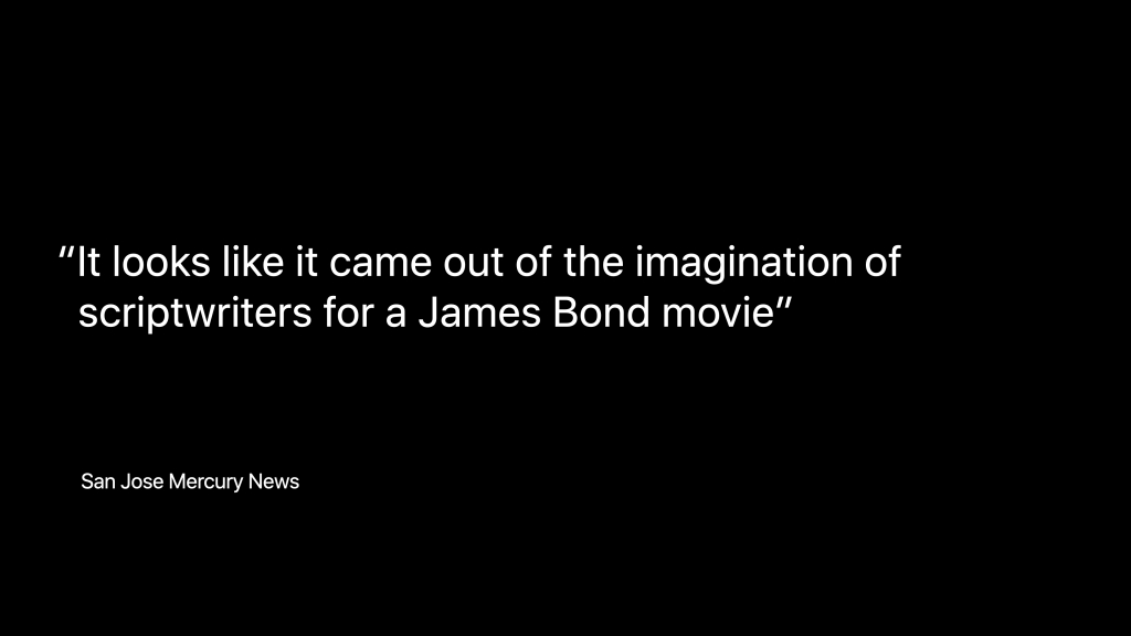
At the time, it was considered out-of-this-world. This is what Silicon Valley’s San Jose Mercury News said about it:
The Etak Navigator launched 39 years (!) ago in 1985. 😱
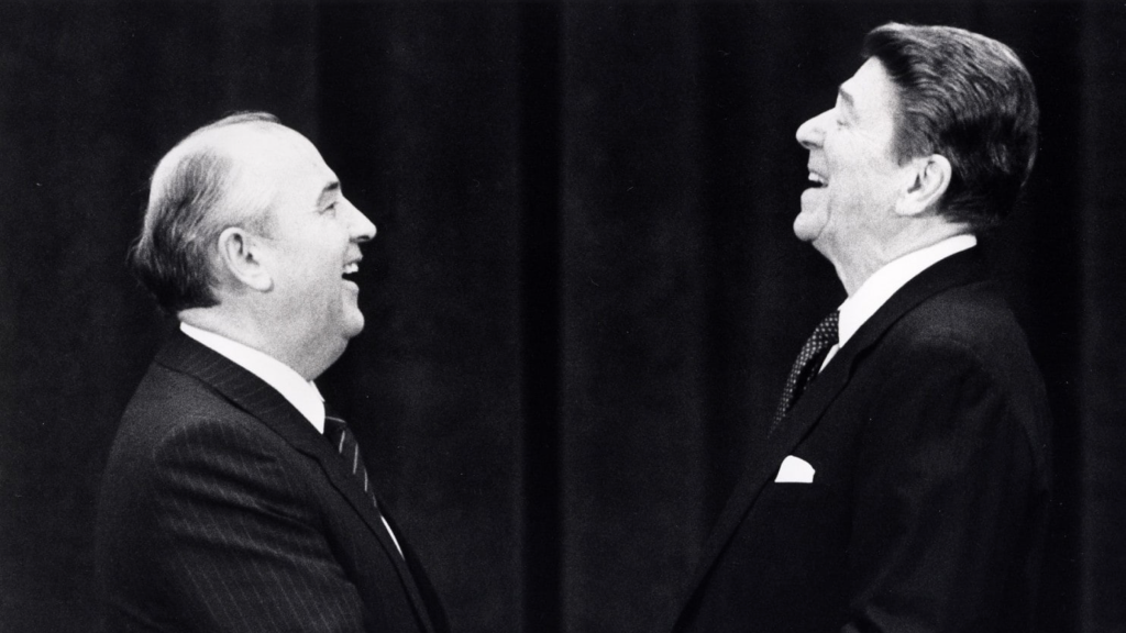
Back then Reagan and Gorbachev were negotiating the end of the cold war.
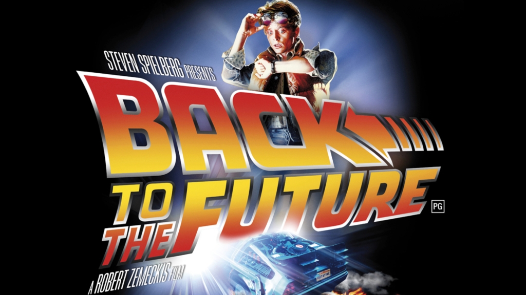
And it was the year Steven Spielberg released the film “Back to the Future”…
And I’m sure at that time many of you were but a twinkle in your mother’s eye…

Back in 1985 you used paper maps to navigate, like this one from a Thomas Brother’s map of Los Angeles:
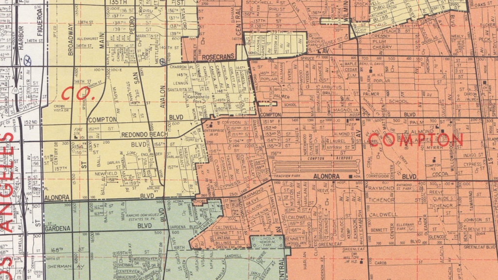
As you can see, the maps weren’t always pretty. By today’s standards it was also supremely difficult and tedious to find locations and even more difficult to work out how to get there.
So, when the Etak Navigator launched, it was like something from the future.
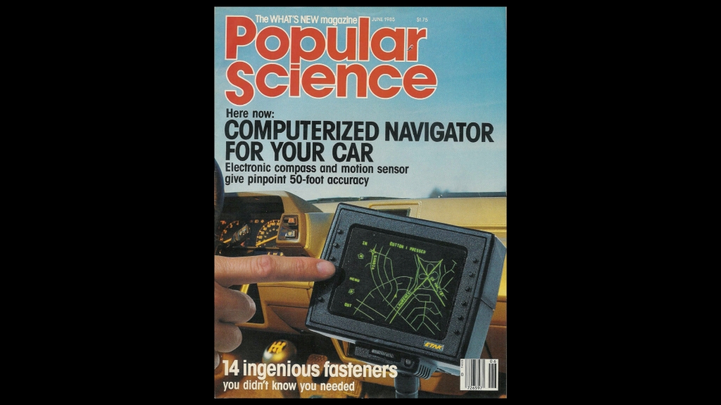
It immediately got tons of press, including the front cover of Popular Science:
Nearly everything about the Etak Navigator had to be conceived from scratch.
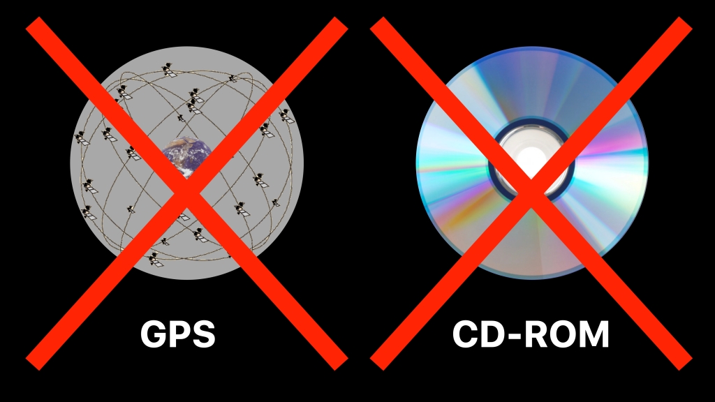
Most important was the self contained positioning system. Remember that back in 1985 GPS was not available (see “12 Map Happenings that Rocked our World: Part 8 — Oh Brother, Where Art Thou?“)
Before GPS, navigation systems used a technique called ‘dead reckoning‘. Dead reckoning relied on sensors to determine distance traveled and direction of travel. However, no sensor is perfect. As a result the further you travel the greater the errors build. Pretty quickly you have no idea where you are.
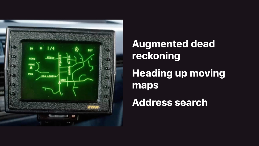
To solve this problem Etak invented ‘augmented dead reckoning’. This used a process to match the position given by the navigation sensors to a topologically correct electronic map. Whenever the vehicle turned you made the assumption that you’re driving on a road. At that point the location could be ‘snapped’ back to the road and the error from the sensors could be reset. This technique was later adopted by all navigation apps and is still in use today.
Like all attempts at building a navigation system before it, without this key invention the Etak Navigator would have failed.
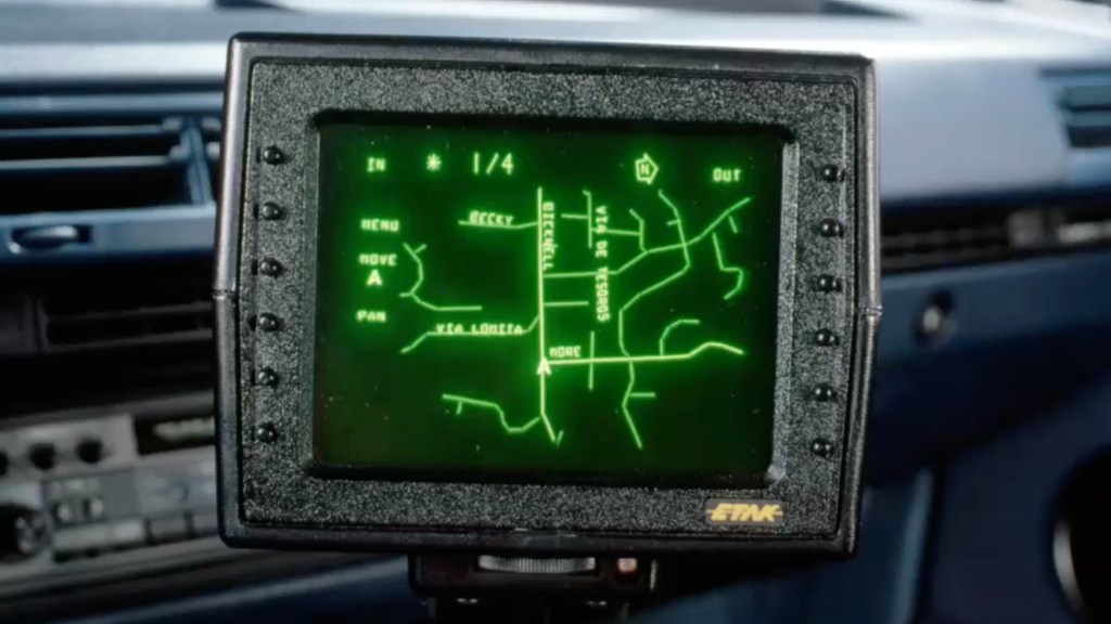
The second key invention was a ‘heading up’, moving map display. This meant that the vehicle remained at the center of the screen and the map moved and turned under the vehicle. What you saw ahead of you in the windshield was what was displayed on the screen. This proved highly intuitive.
Third: the Etak Navigator was also the first consumer device to introduce the concept of address search, or what the geospatial industry has come to call ‘geocoding’.
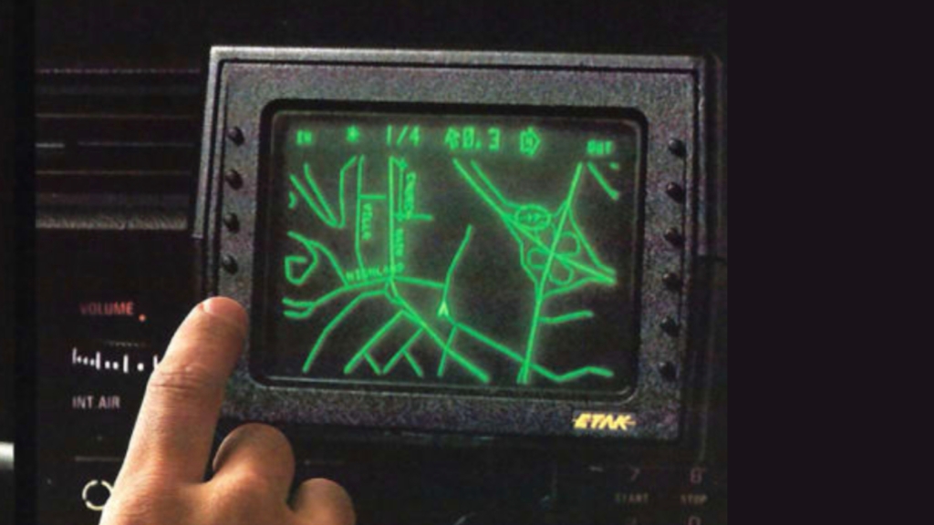
Here is a clip from the only video I could find of the Etak Navigator in action:
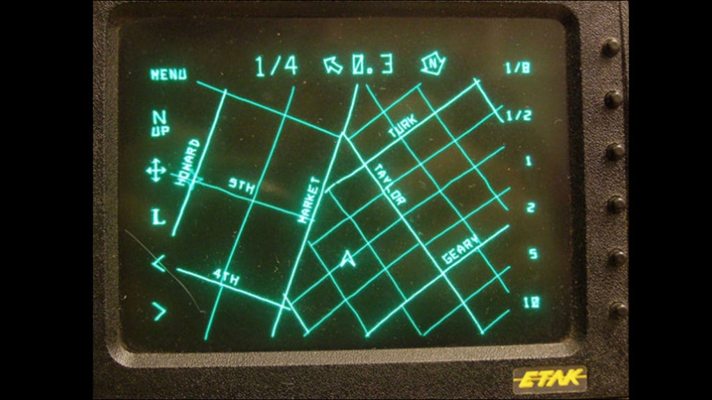
As you can see the map moves and turns as the vehicle drives.
The buttons on the right control the zoom level which is denoted as the number of miles between the vehicle symbol and the top of the screen.
The top of the screen shows the current zoom level, the heading to the destination, the number of miles to the destination as the crow flies, and which way is north.
The address search allowed entry of destination by address, street or intersection. You could also store common locations like home and work.
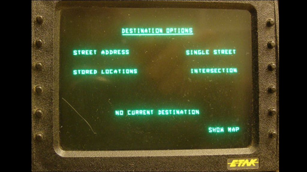
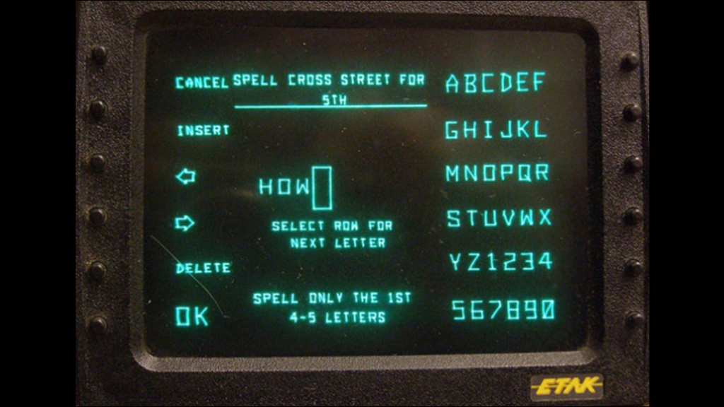
The Etak Navigator had twelve buttons, six on each side of the screen.
These were soft programmed depending on the current function.
In the screen below you can see how street names were entered. Note how any letter or digit could easily be entered with just two button pushes. Also, you only had to enter the first few letters of a street name:
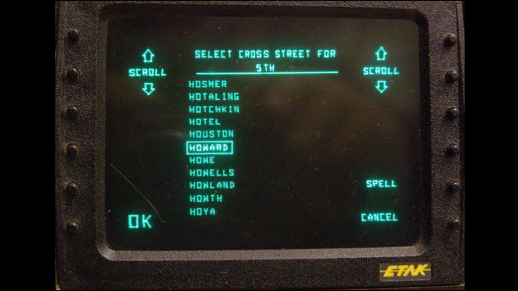
And after that you simply selected the street from a list:
This is the Etak Navigator in navigation mode:
Note that the Etak Navigator did not provide turn-by-turn directions. Instead you simply zoomed out the map to see your destination, shown as a flashing star. As you got closer to the destination you zoomed in revealing more of the local roads. You had to use your own noggin to determine the most appropriate road to take.
The lack of turn-by-turn navigation did not prove to be an issue. I know from much personal experience that the system worked very well!
Etak Navigator System Details
There were five key components to the Etak Navigator:
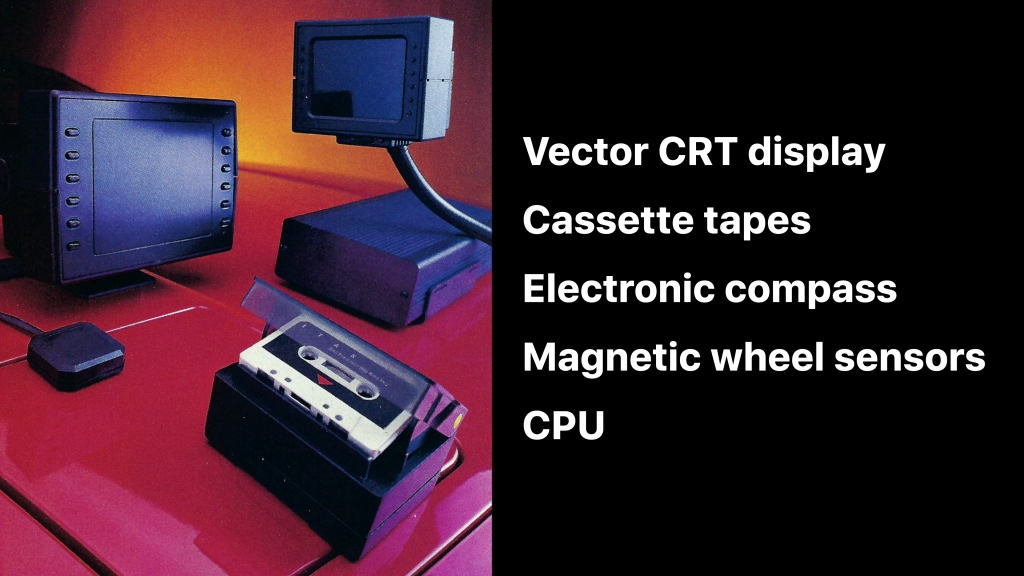
The first was a vector CRT display — similar to what you might find in an oscilloscope.
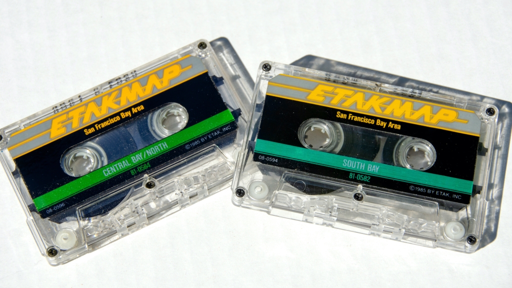
The navigation app and data were stored on cassette tape. The cassette tape drive was specially developed to read the tape at very high speed. In a music player a cassette tape is read at about 5cm (1 and 7/8″) per second. The cassette tape in an Etak Navigator was read at about 200cm (80″) per second!
There was an electronic compass installed on rear window of the vehicle.
To determine distance traveled and to augment the heading info from the compass, magnetic wheel sensors were installed on the un-driven wheels of the vehicle. This involved sticking special magnetic tape on the inside of the wheels and mounting magnetic sensors on the brake calipers.
Finally there was metal box about the size of a shoe box that contained the CPU and motherboard. This was installed in the trunk.
The cassette tapes stored both the navigation app and the map data. The maps were called “Etak Maps”. It took 6 tapes to cover the San Francisco Bay Area:
The original price for the Etak Navigator was US$1,395:
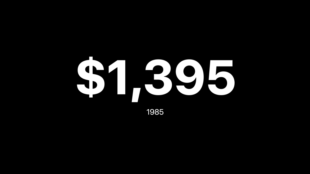
That’s the equivalent of about US$4,000 today.
On top of the cost of the Navigator there was an expensive installation cost: it took an experienced technician about 4 hours to install the whole system.
Just Some of the Technical Hurdles
Back in 1985 there were huge technical constraints.
GPS barely existed. In those days the government prevented anyone but the military getting more than 100 meter accuracy. And GPS receivers were both large and expensive.
In addition there were no large capacity interchangeable media. Floppy disks couldn’t store enough information and CD-ROM technology was brand new and too costly.
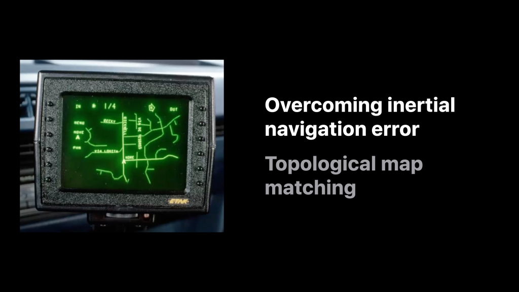
The most important problem to solve was overcoming inertial navigation error from the wheel sensors and the compass.
Here the solution was topological map matching.
This invention, above all others, made the product viable.
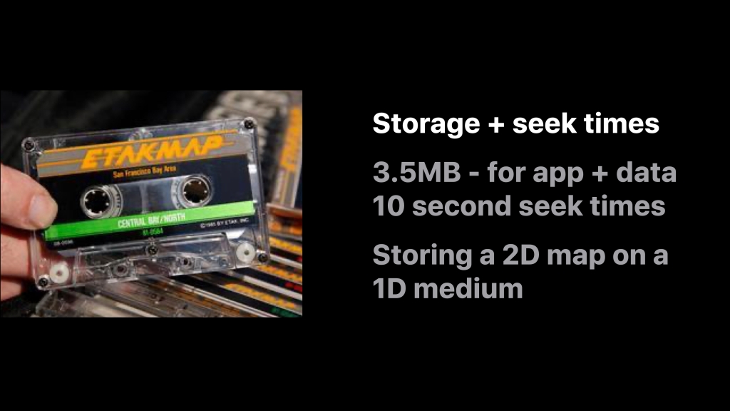
Another issue was data storage and latency.
The cassette tapes only held 3.5 megabytes and had 10 second average seek times.
The dev team had to invent a way of storing the 2D map on a one dimensional medium, making sure that regions close by on the map were also close by on the tape.
Years later, when hard drives became cheaper and CD-ROMs became more readily available Etak’s highly efficient map data storage algorithm paid off in spades and resulted in very high performance maps.
Another problem was heat.
Users commonly left tapes on their dashboards and obviously dashboards can get very, very hot.
You can see from the tests that not all brands of cassette tape did very well:
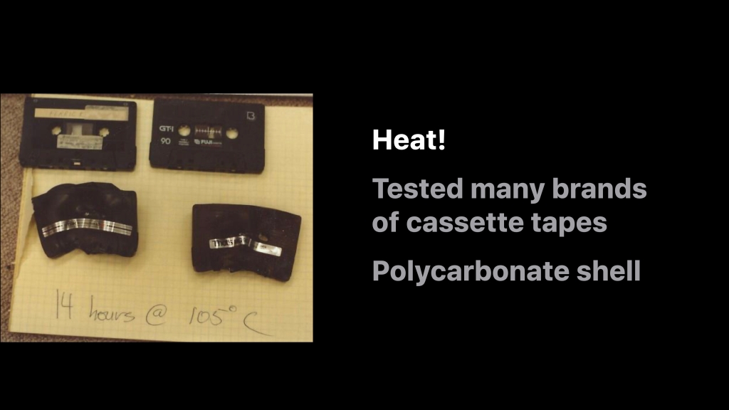
However, a brand that worked was finally found. It had a shell made of polycarbonate.
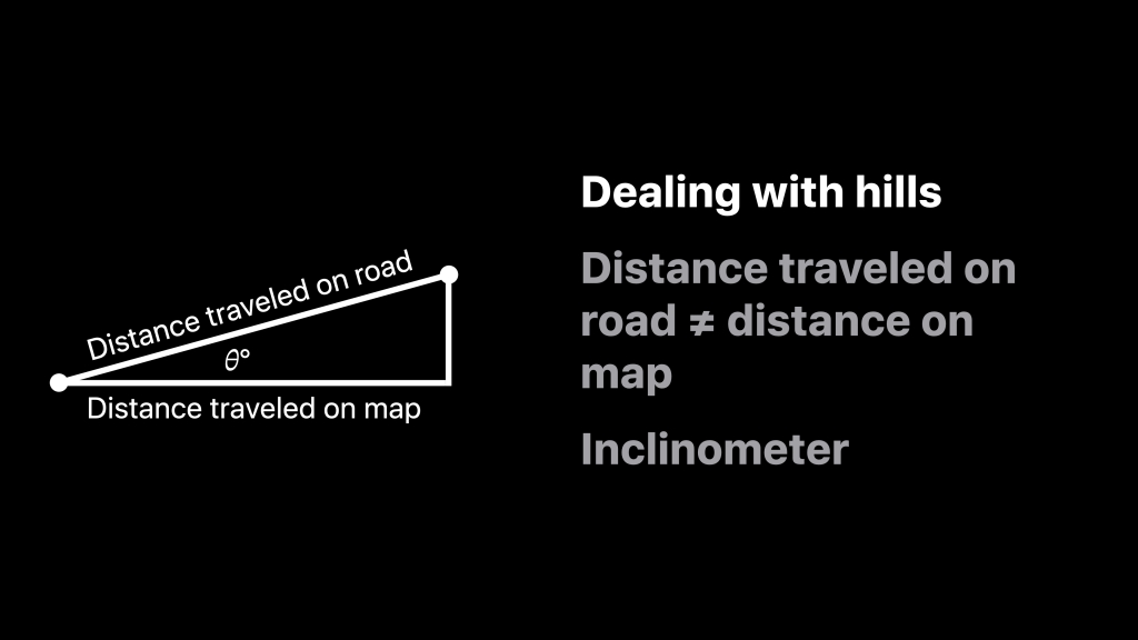
Yet another problem was dealing with inclines.
The map had no elevation information and so if you were traveling up or down a hill errors would be compounded in the system as the distance traveled on the road was not equal to the distance traveled on the map.
To compensate we therefore needed to know the slope of the hill. To compute this Etak’s lead hardware engineer invented a special inclinometer that used fluid and a capacitive sensor. In tests on various fluids he found that Tequila worked quite well!
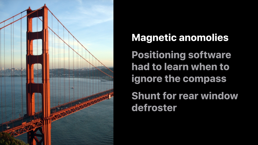
Another problem were magnetic anomalies.
Bridges can be highly magnetic and can really throw off a compass.
The positioning algorithm therefore had to recognize these anomalies. When an anomaly was detected the positioning instead relied on the different speeds of the wheels to determine changes in direction. It wasn’t quite machine learning, but at the time it seemed pretty close!
The system also had to compensate for the magnetic fields generated by the rear window defroster.
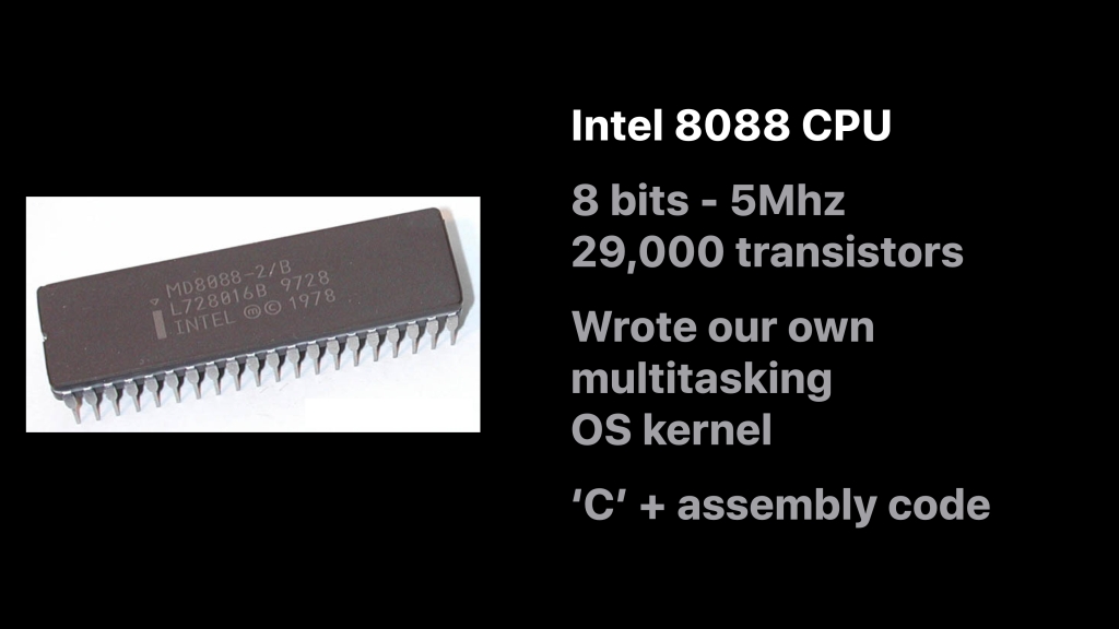
In 1985 there wasn’t the luxury of 25 billion transistors and an M3 chip.
Instead the system relied on an Intel 8088 CPU which had 8-bits, ran at 5MHz and only had 29,000 transistors.
Thus every line of code had to be incredibly efficient. It was all written in C, except for key parts of the OS kernel which were written in assembly.
What about the digital map?
Etak had to create it — more or less from scratch.
Originally Etak thought it could get maps from the government. Back then the US Census Bureau had something called GBF DIME files (which predated TIGER). But they were stick maps and didn’t contain any shape to the roads.
Etak therefore embarked on a massive program to build a map of key metropolitan areas across the US and later in Europe.
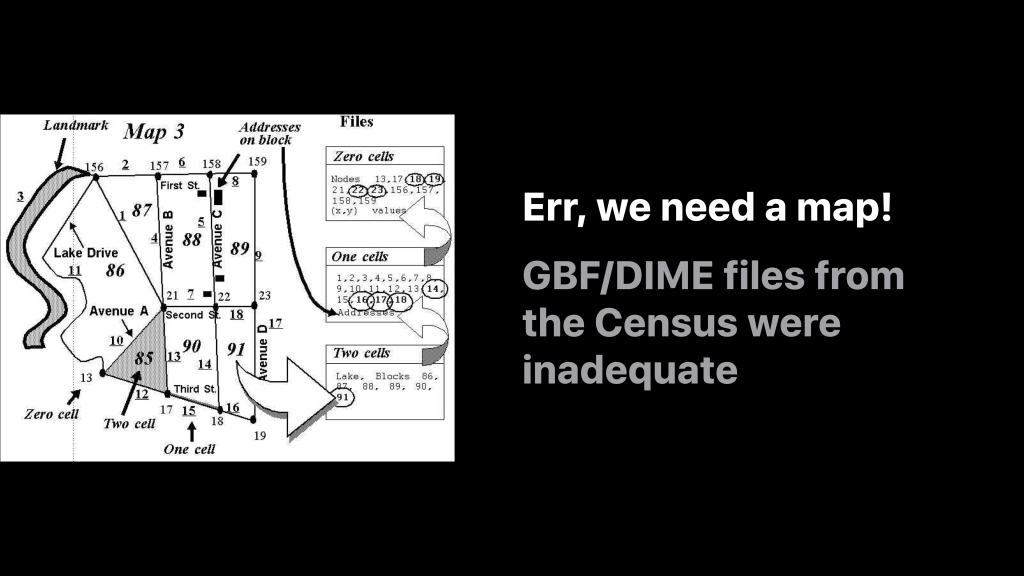
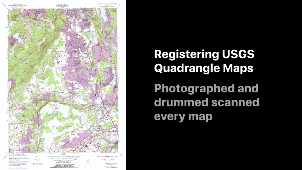
To reposition the GBF/DIME files and give them some shape we used 1:24,000 scale United States Geological Survey quadrangle maps, otherwise knowns as ‘USGS quads’ as a reference.
Each map was photographed onto 10” transparencies and then scanned using a very expensive drum scanner.
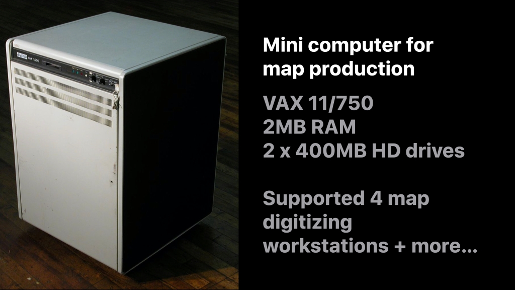
The entire map production program was developed and ran on a single VAX minicomputer. This blazing machine had 2MB RAM and two 400MB hard drives. It cost about US$120,000 in today’s dollars.
This little devil was burdened with a mammoth set of tasks. It supported:
- 4 map digitizing workstations
- The engineers developing and compiling code
- Batch jobs to process and compile all the map data
- The company admins who used it for word processing
This was the coding environment:
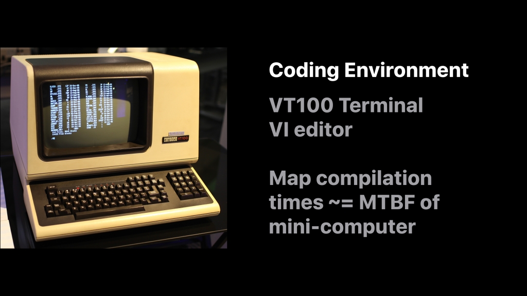
A dumb monochrome terminal.
You edited code using the ‘vi’ editor. Sometimes you waited an hour for your programs to compile.
The jobs to process the map data took up to two weeks to run … which was longer the the mean time between failure for the VAX mini-computer. The engineers used to joke that they should run the long jobs only immediately after a hardware failure had been fixed (knowing full well they were uttering a statistical fallacy).
The map digitizing environment was also revolutionary:
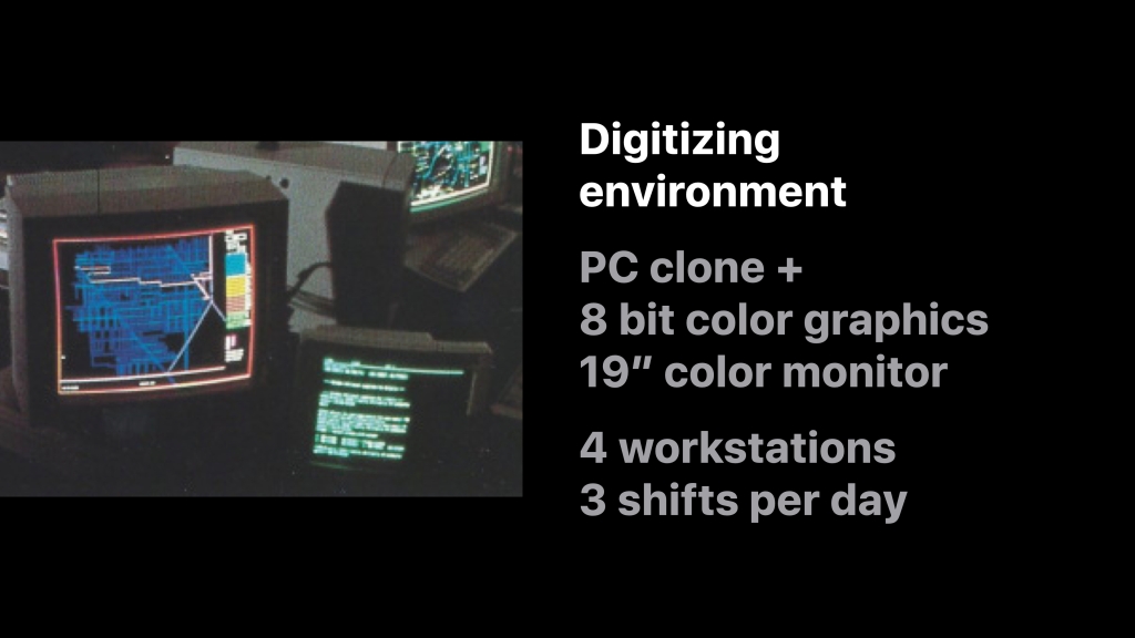
Each digitizing workstation was comprised of a PC clone with an 8-bit color graphics card and a 19” monitor. Initially there were four workstations which were manned by three shifts a day. Later this grew to 36 workstations. Etak digitized maps 24 hours a day, 5 days a week and 8 hours a day on weekends.
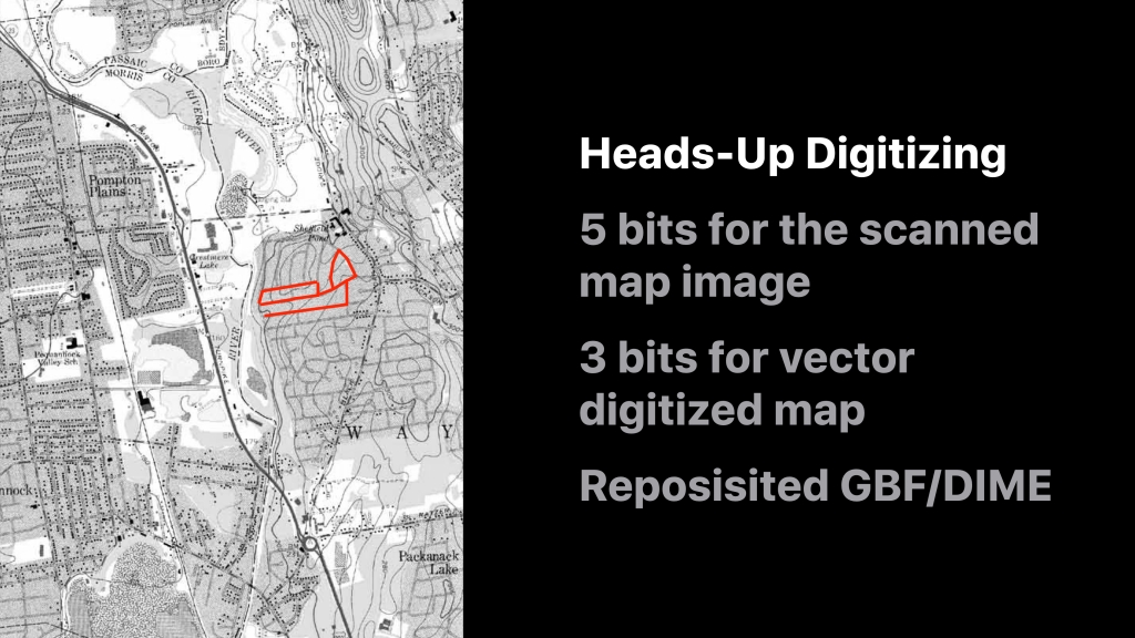
The map editing system was the first ever to use ‘heads up’ digitizing and was a huge trade secret at the time. It was so secret that the methodology was never patented and the digitizing environment was walled off from prying eyes — especially from the CEO of a particular company called ‘Environmental Systems Research Institute‘ — i.e. a gentleman called Jack Dangermond who I’m sure would have leapt at the chance to borrow the concept. 😉
Before this invention people used to digitize ‘blind’ using digitizing tablets which was highly inefficient and error prone.
Etak’s map production system leveraged the eight bits of the color graphics card very efficiently. 5 bits were used to display the scan of the USGS quad in greyscale and the other 3 bits were used to display the digitized map on top. The system was used to reposition the GBF/DIME files as well as to digitize new roads and edit road attributes like street names and addresses:
The Amazing Team Behind It
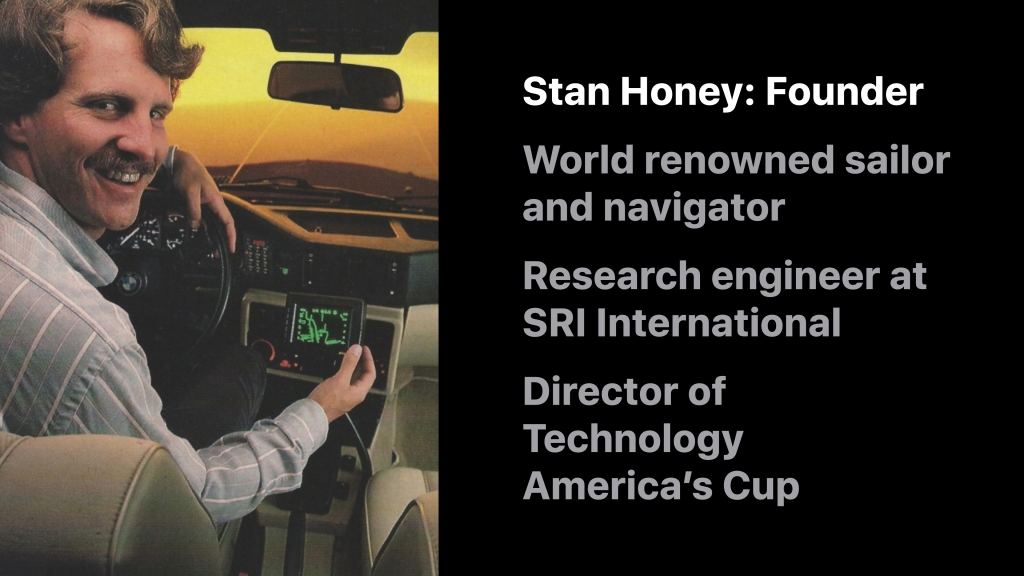
Etak was founded in 1983 by a truly amazing engineer, Stan Honey.
Stan was already a world renown sailor. More importantly he was a world class navigator and had already beaten many sailing records across the Pacific by relying on his navigation skills.
Before founding Etak, Stan was a research engineer at SRI International in Menlo Park, California.
Stan has gone on to do many things. His most recent achievement was as the director of technology for the America’s Cup sailing races where he developed a system to track the America’s Cup boats to within 2cm, five times per second!
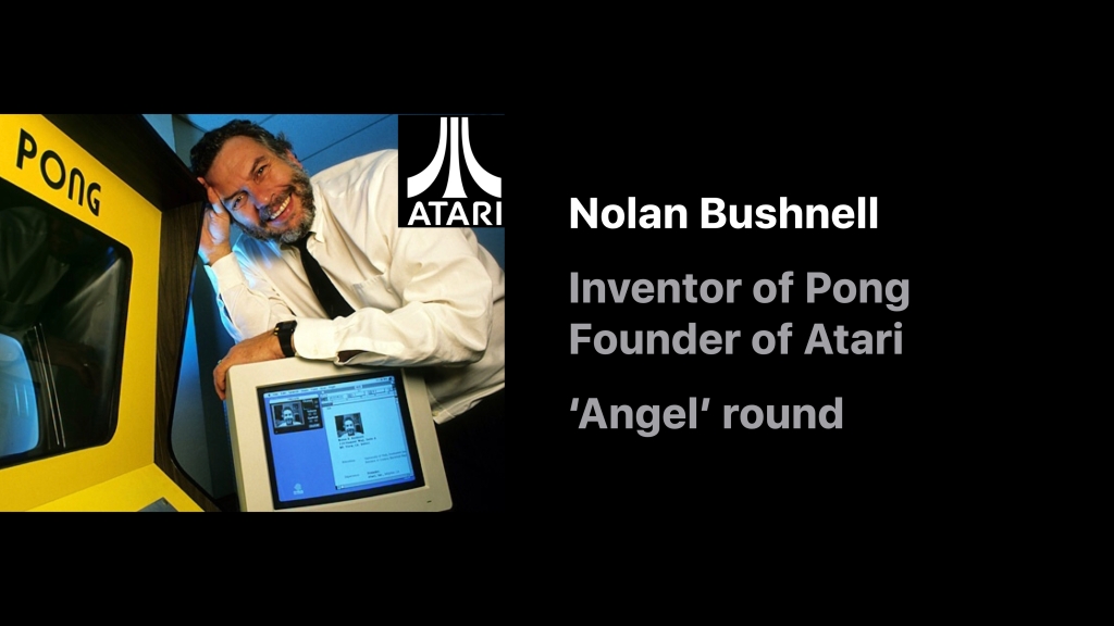
The original idea for Etak came when Stan Honey and a serial entrepreneur, Nolan Bushnell, were on a sailing boat together. Nolan had hired Stan to navigate his racing yacht through the 1983 Transpacific Yacht Race, a prestigious sailing event that spanned 2,225 nautical miles of open ocean from Los Angeles to Honolulu.
Nolan was famous for inventing the first video game, Pong, and later for founding Atari.
The story is recounted by Benj Edwards in his fantastic article for Fast Company: “Who Needs GPS? The Forgotten Story of Etak’s Amazing 1985 Car Navigation System“:
[Early one morning Stan and Nolan were on night watch together.] They began brainstorming about a computer-based navigation system for use on land. Stan thought a navigation system for automobiles could operate based on dead reckoning and comparing one’s current location to known points on a map, a technique known as map matching. It wouldn’t need satellites at all, just a good digital map, a good compass, and some sensors. Then it could display the result on an electronic screen.
Nolan reaction: “Yeah, let’s do that and I’ll fund it”
Nolan always had an appreciation for where consumer technology might eventually go. In an interview for Inc. magazine in 1984 he said “Let’s say you’re in your car, and you want to go to dinner. You’ve got this box on the dash. You punch in ‘Japanese,’ then ‘cheap,’ then ‘good sushi.’ The box takes over and guides you to a place.”
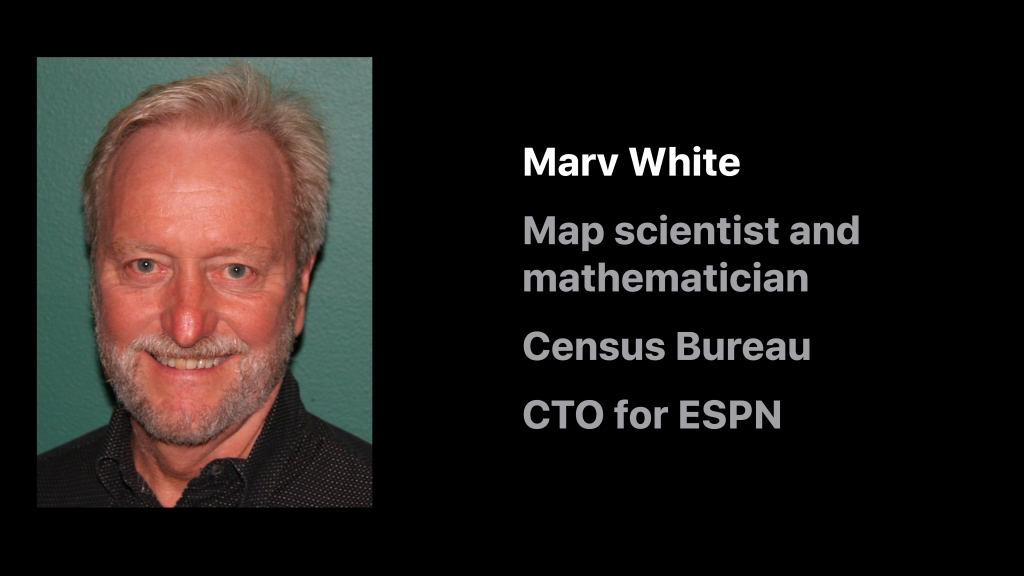
One of Etak’s key hires was Marv White. Marv was a map scientist and mathematician and worked at the US Census Bureau on their mapping program.
Under Marv’s direction Etak’s map digitizing productivity was three times the industry standard. Since leaving Etak, Marv has gone on to many exciting ventures, including a period as Chief Technologist for Innovation at ESPN.
There were many other supremely talented engineers behind the Navigator, many of whom previously worked at SRI International: Ken Milnes, George Loughmiller and Alan Philips to name a few.
Many of the original hires at Etak went on to other mapping organizations, including yours truly. When I worked on the Apple Maps team, 12 of my colleagues were Etak alumni.
Terry O’Brien, Marv White, Walt Zavoli, Alan Philips, Jamie Buxton, Ken Milnes, Stan Honey, Gerry Russell
So What Happened to Etak?
The Etak Navigator was about 20 years ahead of its time. Due to the cost of the hardware and the expensive installation process building a sustainable business proved to be very difficult (sound familiar?)
Instead Etak quickly pivoted. It licensed the navigation code to the biggest automotive OEM hardware manufacturers at the time: Robert Bosch in Germany, GM in the USA and Clarion in Japan. In turn these companies developed their own navigation systems and, many years later, the concept of a ‘Personal Navigation Device’ from the likes of Blaupunkt, Garmin, Magellan, TomTom and many others was born.
During the course of doing business Etak attracted the attention of a perhaps an unusual suitor: Rupert Murdoch’s News Corporation. It was News Corps’ John B. Evans that saw the potential.
Like Nolan Bushnell, John was a supreme visionary. You would often find him on the same platforms as Intel’s Andy Grove, Bill Gates and other technology megastars. Albert Scardino and Matt Falloon recount the story in John’s obituary in the Guardian:
The defining deal of [John’s] career came in the mid-1980s. In 1985, Murdoch invested $350m in a group of travel publications and directories. With one hand, Evans took over the consumer magazine division of Murdoch’s US organisation, including TV Guide, Elle and one he himself invented, Automobile. With his other hand, he launched a secret project in a suburban office building to develop a part of the travel group, the Hotel and Travel Index, into a new media product, codenamed Jaguar.
In the days before streaming video and large file capacity on the internet, travellers’ views of their hotels and destinations were limited to tourist brochures. Jaguar allowed an electronic visual tour of destinations, complete with views of the hotel room they had booked. Once integrated with major airline booking information and other databases and cross-referencing tools, the system threatened to leapfrog other airline, car and hotel reservation systems.
It was thus that John had the vision to use Etak’s maps and technology to benefit the Jaguar system. Thus John convinced Rupert to buy Etak.
Stan Honey recounts the conversations:
John instantly saw the power of maps in media to change the world of classified ads, yellow pages, travel, and broadly answer the questions of “where is the nearest?” and “how do I get to it?”. Naturally, John and my shared sailing background created an instant group of common friends and experience. I remained close friends with John until he passed away and visited him often. Long after John had left News Corp, whenever I was tee’d up in New York waiting for a weather window for a Transatlantic record attempt under sail, I’d always invite John to come visit the boat, which he found fascinating as the boats were 100 foot monohulls or multihulls. I doubt that Etak would have ever appeared on Murdoch’s radar screen without John Evans’ vision and commitment to his vision, and to Etak. At the time of his decision to buy Etak, Murdoch also asked Barry Diller, who was then running Fox, for his opinion. Barry Diller was hard-nosed and direct in his questions, and had a slightly shorter term vision than did John, but Barry also supported News Corp’s acquisition of Etak, and focus on the maps.
John really was a long-term visionary, as was Nolan Bushnell. During the Etak days, both would visit and “wind-up” the Etak crew with their predictions. That was very helpful as the two of them kept our minds wide open. But it was also helpful that they would mostly stay away because we were burdened with the need to actually get things to work, which visionaries seldom are. It is interesting to note that all of the things that Nolan and John predicted, have happened. It is also interesting to remember how far-fetched they seemed at the time of their visits.
But the times there are a changin’: as fate would have it in 1989 Murdoch sold the Jaguar system to Reed International for a profit of $500M. With Jaguar sold the relevance of Etak to New Corp lessened.
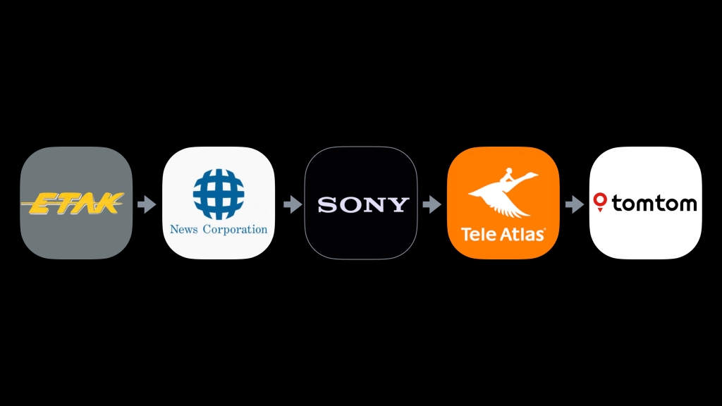
News Corp subsequently sold Etak to SONY, who then later sold it to Tele Atlas. And still later Tele Atlas was subsumed by TomTom. So what was originally Etak is now TomTom:
But Why the name ‘Etak’?
The answer goes back to the early days of Polynesian navigation. In those days the ancient mariners navigated the seas by relying on a series of environmental cues, such as the positions of islands around them.
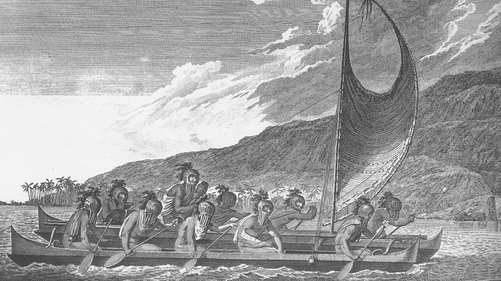
They imagined that that their boats were stationary and that the islands moved past them.
In the same way, in the Etak Navigator the vehicle is stationary and it’s the maps that move past the vehicle…
With that in mind, Stan decided to call his company Etak, which is a Polynesian term for moving navigational reference points.
But Wait, There is One More Thing…
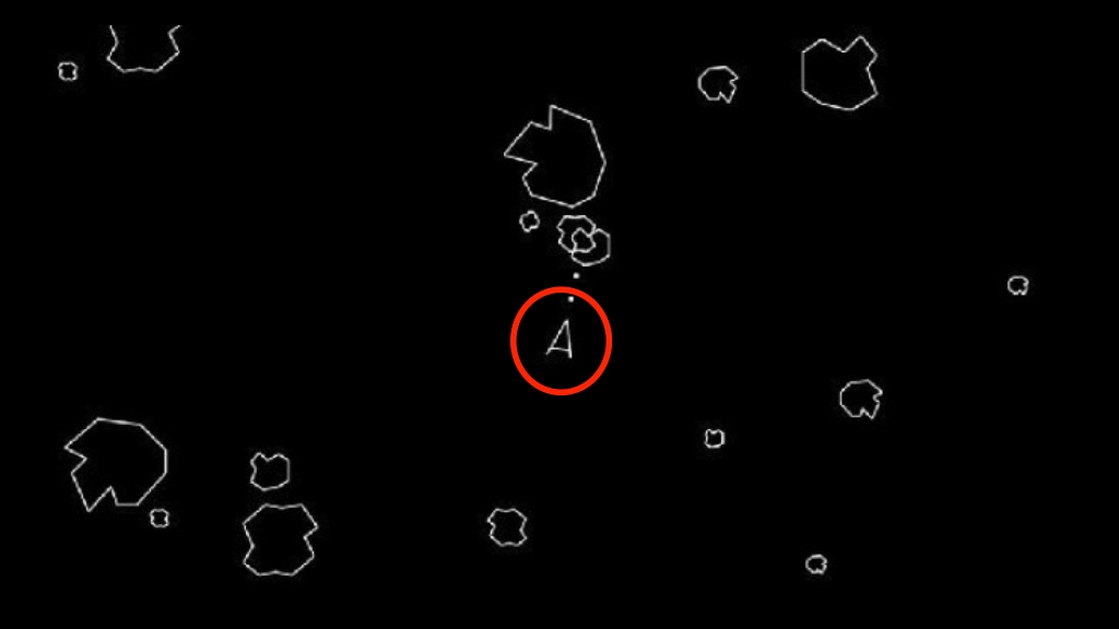
When you look at any consumer mapping app in navigation mode, have you noticed something?
Have you noticed something about the symbol used to denote vehicle location?
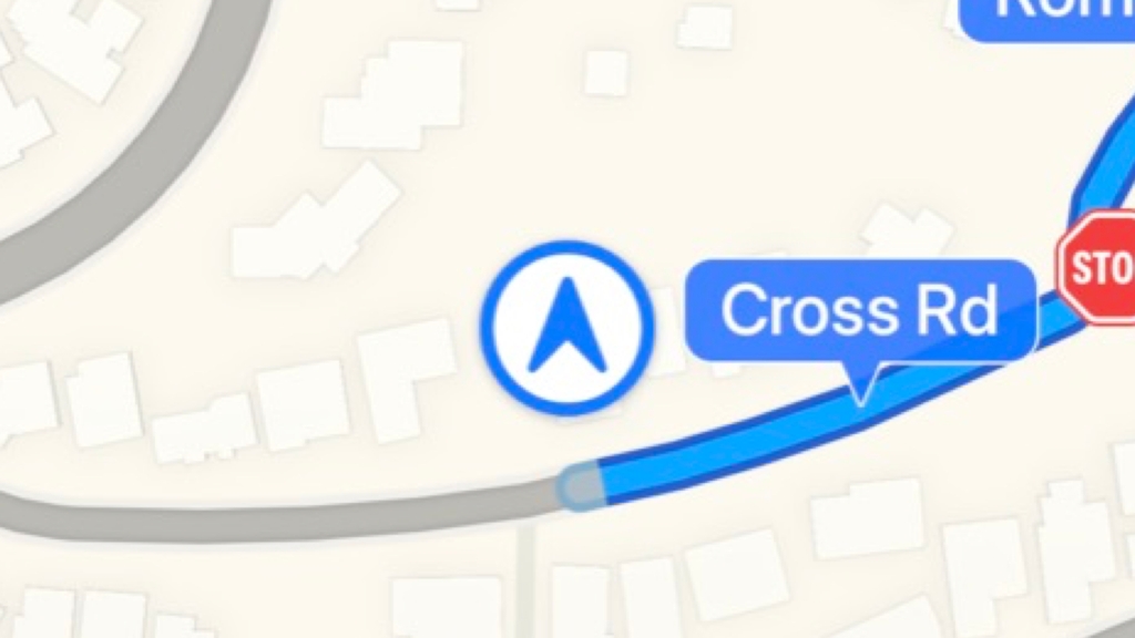
Does it look familiar? Well, of course it does …
So it turns out the symbol used by all navigation apps today is the same one originally invented by Etak.
But why did Etak use that particular symbol?
If you talk to the engineer who wrote the original code, George Loughmiller, he’ll be meek and tell you that it seemed like a good idea at the time. But you have to remember one thing: Etak was incubated by Nolan Bushnell, founder of Atari. And at that time both Etak and Atari were housed in the same office building at 1287 Lawrence Station Road in Sunnyvale, California.
Because Etak used a vector display with limited CPU, George needed a symbol that didn’t burden the very scarce computing resources. He also needed a symbol that was easy to read. A traditional symbol for a car — 🚗 — required too many lines. It also didn’t clearly connote direction. Something simpler was needed.
Legend has it that one of Etak’s engineers got to see a pre-release demo of one of Atari’s latest games. And that game was…
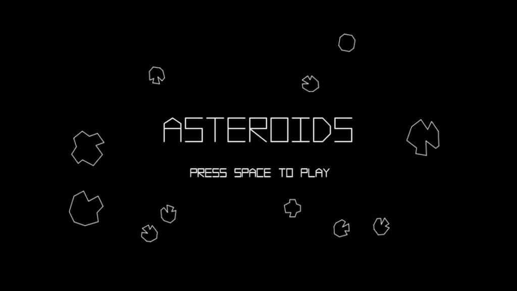
And what symbol did Asteroids use for their spaceship?
And thus the symbol for vehicle navigation was born and is still used by all navigation apps globally today:

So There You Have It…
Every once in a while, a revolutionary product comes along that changes everything.
Etak’s many significant inventions included:
- the world’s first in-vehicle nav system that actually worked
- augmented dead reckoning using map matching
- moving map heads up display
- first use of geocoding in a consumer application
- algorithms for highly efficient map data storage and retrieval
- heads up digitizing
- the world’s first high volume digital map production system
- inventor of the universal map navigation symbol
I was but a pimply engineer at the time. Little did I know when I joined Etak in 1985 that I was going to be part of such an illustrious team.
My hats off and best wishes to everyone I worked with: it was a privilege, an honor and an amazing journey. Thank you.
Acknowledgements, Further Reading & Watching
- Stan Honey, Marv White and the rest of Etak team
- Benj Edwards: “Who Needs GPS? The Forgotten Story of Etak’s Amazing 1985 Car Navigation System” (2015, Fast Company)
- Popular Science Article from June 1985: Credit: Stan Honey and Popular Science Magazine
- The Etak Business Plan: May 10, 1984: Credit: Computer History Museum
- Rare and interesting documents about Etak: Credit: Computer History Museum
- Etak Innovations: Credit: Stan Honey
- Etak’s Initial Product Brochure from 1985: Credit: Stan Honey
- Paper presented at the Royal Institute of Navigation meeting in York 1985: Credit: Stan Honey
- Etak Navigator Tour & Demo: Credit: EllsworthC on YouTube:
